The first of these posts is a case study of Lindisfarne, or Holy Island, a tidal island off the Northumberland coast, near the Scottish border - for no better reason other than that I happened to be there on Saturday (I've spent the last four days driving and hiking around the far North East of England). My aim here is to answer the most simple of the questions posed: what might a 6-mile hex contain?
Lindisfarne is about 2.5 miles East-West and 1.5 miles North-South - easily enough to fit into a 6 mile hex, together with the surrounding coast and smaller islands:

This makes it ideal for our purposes of investigating how many interesting locales there might be for an 'adventurer' (or law lecturer on holiday) to interact with.
Let's take a look at what's on Lindisfarne (while entering the necessary caveat: I was taking photos on my BlackBerry, which is shit, and I'm also a shit photographer, so don't expect anything decent).

This is a view across lush pastures to Lindisfarne castle, a small fortification on the only real promontory on the island. Note the flooded areas in the middle ground. These are extremely difficult to cross and would have to be worked around. Note also how big this area is. It's only a small part of the island, but it's still a large area of ground. To the right is a narrow road and a collection of houses which, today, house the local branch of Her Majesty's Coastguard.

A typical farming cottage with a wide expanse of pastures for sheep grazing around it. One of several on the island. It may just be a farmhouse, but who lives in it? What's his or her story?

The village of Lindisfarne itself. The population is around 150. As well as houses, there is a distillery for brewing mead, a few churches, a graveyard, a quayside, and a ruined priory which we shall re-examine later.

A flooded pasture, which harbours about three dozen geese. Or, if you prefer, a monster of some kind. Or, both.

An old lime kiln to the rear of the castle. This is a warren of tunnels, about 100 yards square, where people used to fire lime stone to make bricks.

The view to the rear of Lindisfarne castle. Again, a wide area of open ground, and plenty of sheep. What you can't see is that this area is boggy underfoot and difficult to walk over, and criss-crossed with rivulets which have to be jumped over.

More flooding - the pool is well over a foot deep. At the brow of the hill is a walled garden area which is strangely pristine and fertile given the bleakness of the surroundings; it could easily be imagined to be magical, or owned by a witch, or similar.

Pebbly beach stretches around much of the Northern and Eastern coasts of the island. It is covered with flotsam and jetsam - broken crockery, sheep bones, crab shells, etc.
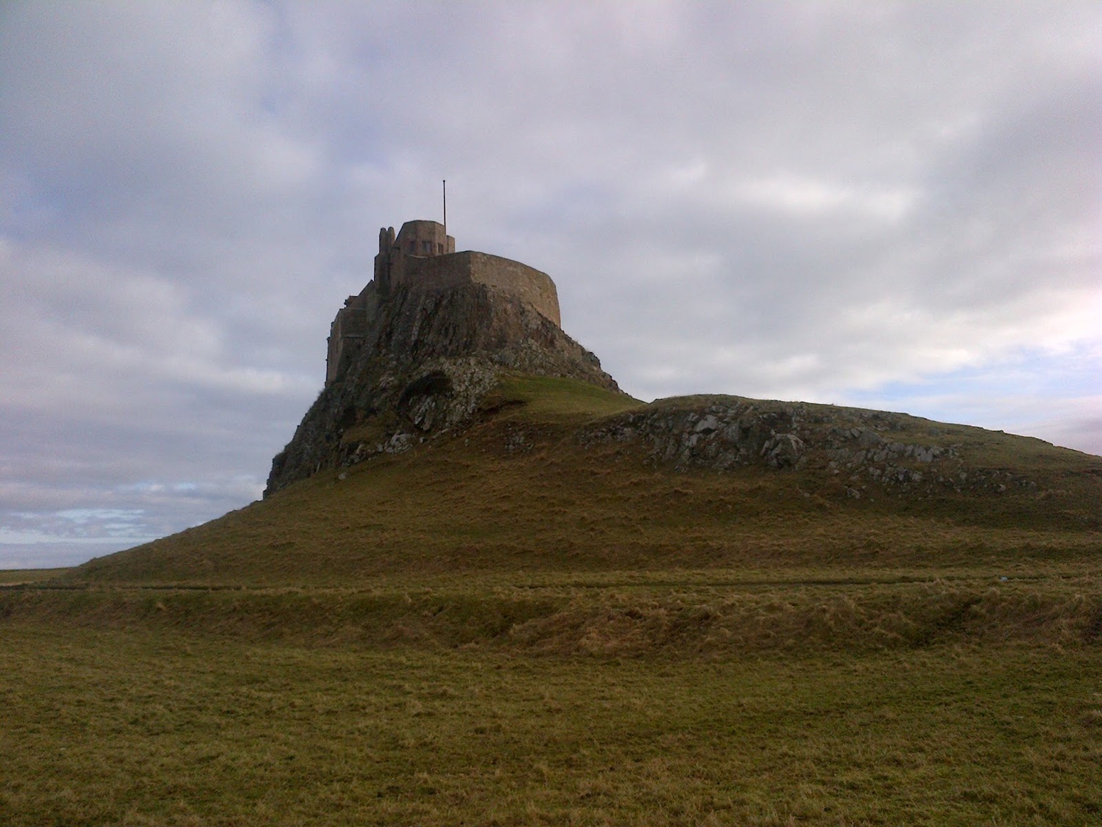
Looking up at the castle.

Looking over the sea towards the mainland. All of that area is included within the 6-mile hex: the islet in the middle of the channel, and the coast beyond, dotted with farmsteads and small hamlets.

A cemetery overlooking the sea, complete with creepy mausoleum.

Coming up a steep hillside to a church and cemetery. A spooky and evocative location, even on a sunny winter's day.

A view over the channel to the smaller island to Lindisfarne's south. I have no idea what those two towers are, but studying them was my obsession the day I was on the island. They look pretty much exactly where I would expect a pair of squabbling arch-mages to live. Again, they are within the bounds of a 6 mile hex centred on Lindisfarne.

A better view of the small islet. There is a low building of some description on it, as well as a shrine (you might just be able to make out the crucifix there).

I don't know if this is actually a well, or just a flooded dungeon or basement. There is clearly something down there worth exploring, though, don't you think?

The old priory. An extensive ruin, full of dark arch ways and unexpected corners.

A ruined watch tower overlooking the entrance to the harbour.

Another view of the ruined watch tower. Is it haunted? Is something buried underneath it? Does it harbour a hermit, a group of brigands, an evil spirit?

Boats turned upside-down and converted into huts - apparently a tradition from the Viking days. Probably housing suspicious fishermen, but I bet you can think of a dozen interesting things you could put here as a DM.

Detail of the doorway to an abandoned farm building down by the beach. Peeking through a gap I found a lot of hay and some abandoned farm machinery, but again, I bet you can think of a dozen more interesting things you could put inside as a DM.
These potentially important locales are only a taste of what is on Lindisfarne - let alone the surrounding area of coast which would potentially be covered in a 6-mile hex hex here. Put simply, there is a huge amount of game-able material just in this very tiny piece of land.
As a DM, of course, coming up with a list of 15 interesting locations for each 6-mile hex before the start of a campaign would be overkill, but there is certainly an argument to be made that at the very least each 6-mile hex in a campaign setting, particularly in a settled area, should have a handful of adventure locales within it, with more arising through improvisation during play and through random encounters. One locale per hex, or even blank hexes, simply aren't good enough.
Tomorrow: thinking about actual wilderness travel.
Excellent post -- and clever way to share your vacation pics without annoying others.
ReplyDeleteThanks. There are more coming up - I won't stop until it is past annoying.
Delete>> One locale per hex, or even blank hexes, simply aren't good enough.
ReplyDeleteWhen I begin a campaign, which happens quite rarely, the map tends to be about 10 miles by 10 miles for the first three levels of experience which takes many sessions. However after this introductory the resolution at which adventurers potter about coarsens, in the main because purposeful travel to a location 100 miles distant will open up only thin slices of your six mile hex to the travelers. The judges guild wilderlands style prepared representative encounters for a five mile hex assuming this kind of traveling through. Loitering clearly requires extra work from the DM. It is a different matter if each hex is being thoroughly explored of course. I don't game in the so-called 'sandbox' manner.
I would also note that terrain need not be as charmingly variegated as the English countryside on the small scale. Ive been looking at Africa recently and made a map with 150 mile hexes, which I will supplement with maps of 15 mile hexes for regions of interest. You have to take a practical approach where vast terrains are considered.
I agree that a practical approach is called for, but while Africa may not be as charmingly variegated as the English countryside, it is still variegated. What it loses in man-made locales it gains in wild animals, areas of geographical interest, etc.
DeleteExcellent post noisms! I absolutely agree that there is potentially so much more adventure to be found within a 6-mile hex than the orthodox approach would have us believe. I think especially within the strictures of the mediaeval paradigm where common people rarely went more than a few miles away from their home over the course of a lifetime, roads were terrible and often impassable and every landmark was endowed with some sort of mythic significance that there could easily be 10 or more game-able sites in such an area.
ReplyDeleteI personally have a distaste for hexifying everything but think that maybe a variety of hex sizes might be an interesting approach (as Kent). Especially as a means of modelling relatively tame vs. wild vs. infernally hellish-type landscapes.
Also, being Australian, I am jealous of your capacity to access mediaeval ruins, I've toyed with the idea of photgraphing the archaic gondwanan rainforest on extinct volcanic caldera in which I live and work and keying it out as adventure locations, but the ruins are mid-twentieth century banana plantation infrastructure and not so evocative. I'd love to see the setting you've photographed keyed out as a fantasised Landisfirne (or whatever)with suitable encounters (lost berserkers, revenant monks etc.)
It's probably even better for a quasi-historical campaign like Pendragon, or maybe a 2nd edition AD&D viking campaign run through the vikings historical source book.
DeleteI think the "towers" to the south may be maritime monoliths looking that the satellite pictures they look pretty similar one that's located on Lindisfarne itself.
ReplyDeleteThe "towers" to the south:
https://maps.google.com/maps?q=Holy+Island,+United+Kingdom&hl=en&ll=55.657884,-1.794277&spn=0.001207,0.003406&sll=37.0625,-95.677068&sspn=54.884801,111.621094&oq=holy+island+&t=h&hnear=Holy+Island,+Northumberland,+United+Kingdom&z=19
The one on Lindisfarne:
https://maps.google.com/maps?q=Holy+Island,+United+Kingdom&hl=en&ll=55.68546,-1.779501&spn=0.002413,0.006813&sll=37.0625,-95.677068&sspn=54.884801,111.621094&oq=holy+island+&t=h&hnear=Holy+Island,+Northumberland,+United+Kingdom&z=18
And a ground-level photo:
http://www.flickr.com/photos/tjblackwell/5837788218/in/set-72157626973462078
While they aren't as neat as warring Wizard's towers, I'm totally adding some navigation monoliths to the coastal areas of my campaign now. :-)
In my own campaign I'm aiming to define a variety of specific locations, and then use random locations for the rest.
One idea I just had was to define a bunch of locations appropriate for a whole area, and then randomly pick one when I need a location for a hex. As I start to run out of pre-defined locations, I can define some new ones.
Obviously you'd want a reasonable number of pre-defined locations so that your players could hear rumours about them and the like, but even then when they ask about an area, you could randomly generate the encounters they hear rumours about and define where they are based on that. And some locations would need to be pre-defined because they are fairly specific in their requirements.
No pic of the Emmanuel Head navigation pyramid?
ReplyDeleteFascinating post - and for even more D&D cred, isn't Lindisfarne the home of the real-world Saint Cuthbert? ;-)
ReplyDeleteCool post! Question: is a 1-mile hex a hexagon that has sides of length 1-mile or one that has an area of one square-mile?
ReplyDelete1 mile top edge to bottom edge. At least that's how I always use it.
DeleteWow - love the photos: as a Californian, it is really great to see this perspective on this historic sight from a gaming perspective; how great would it be to see details like this from assorted walks from interesting places around the world? Right about now, I don't think Fitzgerald realizes how intreguing an Aussie bannana plantation actually sounds... SMITH
ReplyDeleteYeah, I thought that too. Aussia banana plantation? Sounds perfect for an Australia-based Call of Cthulhu campaign, for some reason.
Delete